Subject: Marine Geospatial Ecology Tools (MGET) help
Text archives
| From: | "Jason Roberts" <> |
|---|---|
| To: | "'Adam Bausch'" <> |
| Cc: | <> |
| Subject: | RE: [mget-help] Convert MERIS_L2_FRS hdf to ArcGIS Raster |
| Date: | Thu, 8 Nov 2012 14:54:03 -0500 |
|
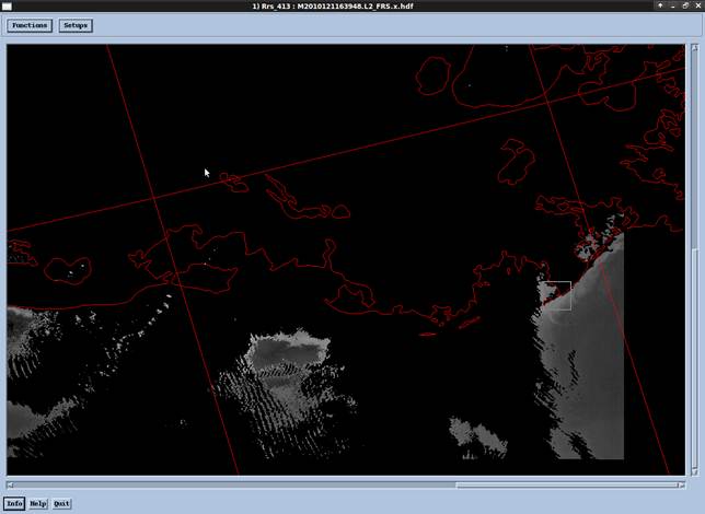
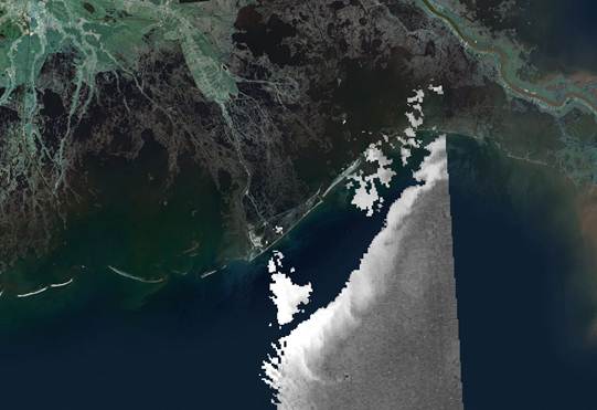
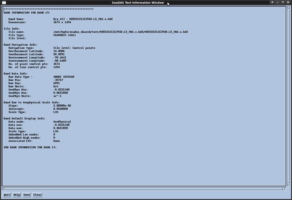
Adam, Yes, you need to run the values through the scaling equation with the slope and intercept. They do it that way so they can store the data as 16-bit integers rather than 32-bit floats, cutting the file size in half. Jason From: Adam Bausch [mailto:] For the Rrs issue. Are the geophysical units the values that should get me the Rrs? Meaning that If I run my raw raster through a linear equation with defined slope and intercept, I should have the remote sensing reflectance values that I am looking for? Adam Bausch From: Jason Roberts [] Adam, Also, I forgot to address your question about Rrs. My understanding is that yes, it should be unitless, 0 to 1 (proportion of incident light that is reflected). If you are wondering about the sr-1, look at this. HTH, Jason From: Jason Roberts Adam, Unfortunately I do not know of an easy way to work with L2 data in the current versions of ArcGIS (10.1 and earlier). Although L2 data typically come as 2-dimensional arrays in HDF or netCDF format, ArcGIS cannot currently understand how to georeference those arrays (unlike SeaDAS, which does understand them). The problem is that ArcGIS requires that all cells in an image have the same cell size. Unfortunately L2 data do not meet that requirement. L2 images are swaths or strips observed by the satellite. Cells near the center of the swath are spaced closer together than cells at the edge of the swath. ArcGIS does not know how to handle that. When people encounter this problem, they naturally think it is an issue with projections—they suspect they are not using the right projection or the right parameters. Unfortunately that is not the problem. There are no projections you can use in ArcGIS that will allow you to georeference swath data correctly (at least that I know of). To work around this you can either: 1. Use SeaDAS to interpolate a raster image that does have a constant cell size, using a format that ArcGIS can read. GeoTIFF is a common choice here. 2. If you are using MODIS data or other data in HDF-EOS format (I think MERIS will qualify), the MODIS Reprojection Tool (MRT) can do the same thing. The advantage of this over SeaDAS is that you can get a Windows version of the MRT. (SeaDAS requires you to run Linux in a virtual machine, at least the last time I checked, which can be complicated if you are used to Windows, and requires a lot of resources.) 3. Use a geoprocessing tool I wrote to convert HDF-EOS L2 data to a point feature class, then use ArcGIS to interpolate a raster from that data using whatever projection and cell size you desire. This might be preferable if you prefer to work within ArcGIS and not learn a new tool like SeaDAS or MRT. But the HDF à Points à Raster workflow can be slow if you have many files to process. If you want to try this approach, let me know and I’ll send you the tool. (Eventually I’ll put this tool into MGET, once I can write a faster version of it.) Hope that helps, Jason From: Adam Bausch [] Hello, I am a former Duke MEM and I’m trying to process some MERIS L2 FRS data obtained from the Ocean Color portal. Before retrieving the data I had the imagery subset to the Gulf of Mexico region. When viewing the image in Seadas (below)
the image footprint appears correct but when I use your MGET import HDF to ArcGIS raster tool, the image is shifted east and south when reprojected to NA Albers Equal Area Conic. I might have made the erroneous assumption that the original Ocean Color data were in WGS1984. One question, is the input GCS correct? I filled in the script output parameters to those of the seadas band file (below). Assuming that the input cell size in decimal degrees is 0.002727 and the final output should be 300m. Where am I going wrong? Also, I thought the L2 Rrs was a unitless value from 0-1 but from the band info that isn’t the case. I appreciate any assistance you can lend to set me straight.
All the Best, Adam Bausch Adam Bausch This email and its attachments may contain confidential and/or privileged information for the sole use of the intended recipient(s). All electronically supplied data must be checked against an applicable hardcopy version which shall be the only document which Cardno warrants accuracy. If you are not the intended recipient, any use, distribution or copying of the information contained in this email and its attachments is strictly prohibited. If you have received this email in error, please email the sender by replying to this message and immediately delete and destroy any copies of this email and any attachments. The views or opinions expressed are the author's own and may not reflect the views or opinions of Cardno. |