Subject: Marine Geospatial Ecology Tools (MGET) help
Text archives
- From: Jason Roberts <>
- To: mostafa awad <>
- Cc: "" <>
- Subject: RE: [mget-help] using MGET in time series analysis
- Date: Thu, 4 Aug 2016 13:00:48 +0000
- Accept-language: en-US
- Authentication-results: spf=none (sender IP is ) ;
- Spamdiagnosticmetadata: NSPM
- Spamdiagnosticoutput: 1:99
|
Hello Mostafa,
Assuming you have a time series of points in a shapefile or geodatabase feature class, the procedure is:
1. Make sure your points have a field that has the ArcGIS DATE data type. If you have dates stored in some other way, such as individual fields for year, month, day, and so on, the MGET tools for extracting the data will not work. In that case, add a field with the DATE data type and populate it using the Calculate Field tool or some other means.
2. Add a field to your points with data type FLOAT or DOUBLE to receive the SST values.
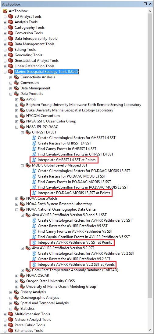
3. In ArcGIS, open the ArcToolbox window. Drill into Marine Geospatial Ecology Tools à Data Products. Below this node are a number of different toolsets for accessing data. Drill into the ones named NASA JPL PO.DAAC and NOAA National Oceanographic Data Center. Look for tools named Interpolate. These are tools that accept a time series of points and extract the values of a data product. Here’s a screen shot of some of the ones you might try:
Each product has unique advantages and disadvantages relative to the others. You will need to research the products themselves in order to understand which one is best for your scenario. If you describe your scenario here I might be able to offer some advice. If you have no idea where to start, I suggest MODIS L3 SST if your points are from July 2002 or later (use MODIS Aqua) or February 2000 (use MODIS Terra). If your points precede this, use AVHRR Pathfinder V5.2 SST if you want daily SST estimates. If the daily estimates are too cloudy, you could try AVHRR Pathfinder V5, which is an older product but offers multi-day averages to fill in clouds.
If you are very concerned about the problem of clouds, consider using one of the GHRSST L4 SST products. These blend data from multiple satellites and use advanced algorithms to fill in clouds. There are many GHRSST L4 products, produced by different institutions for different regions and purposes. You should read about each of them on the NASA PO.DAAC website.
After you open the tool, you should see documentation for it on the right side of the dialogue box. If you do not see it, click the Show Help >> button. You can read about each parameter of the tool. Most of them are optional. The default values of the optional parameters are usually sufficient for most situations.
Best regards,
Jason From: [mailto:]
On Behalf Of mostafa awad
Hello I am mostafa in USF university -college of Marine Science pleasei I would like to have atutorial or helping on how to use MGET TO extract sea surface temperature from NOAA and MODIS satellite pictures for time series analysis . Thank you
|
- [mget-help] using MGET in time series analysis, mostafa awad, 08/03/2016
- RE: [mget-help] using MGET in time series analysis, Jason Roberts, 08/04/2016
Archive powered by MHonArc 2.6.19.