Subject: Marine Geospatial Ecology Tools (MGET) help
Text archives
- From: Jason Roberts <>
- To: "Lenka Fronkova (Cefas)" <>, "" <>
- Subject: RE: [mget-help] Cayula-Cornillon
- Date: Tue, 26 Jun 2018 19:02:29 +0000
- Accept-language: en-US
- Spamdiagnosticmetadata: NSPM
- Spamdiagnosticoutput: 1:99
|
Hi Lenka,
Thanks for your interest in MGET. I have not used the “Spyder” platform before so am unsure how it works. But my guess is that Spyder is running its own installation of the Python interpreter and that MGET is not installed to the site-packages directory of that interpreter. The packages named GeoEco are from MGET. (Internally, parts of MGET are called GeoEco.) Another thing to watch out for is that MGET can currently only run with 32-bit Python 2.x. It cannot run with 64-bit Python 2.x, or any version of Python 3.x.
Once you get that sorted out, you should be able to use MGET from Python if you have some skill with Python. There is some documentation but we don’t have enough resources to complete it or really support MGET as a real API. So you will largely need to rely on your own skill here.
If you simply need to process a directory tree of rasters, it is possible to do so from ArcToolbox. There is a tool called “Find ArcGIS Rasters and Find Cayula-Cornillon Fronts”. This tool can search a tree of rasters, execute the Cayula-Cornillon algorithm on each of them, and write fronts rasters to an output directory.
Hope that helps,
Jason
From: Lenka Fronkova (Cefas) <>
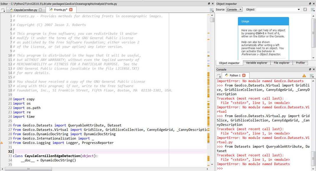
Good afternoon, I am a GIS Analyst at Cefas and we are looking into identifying fronts using SST in the East North Atlantic. I installed MGET and tried Cayula-Cornillon edge detection algorithm and it yields good results in ArcGIS Toolbox. However, I would like to use the code in a loop as we have monthly data in 10 years timescale as a standalone script. I found scripts in “OceanographicAnalysis” “Fronts.py”. When I try to run this in “Spyder” platform it does not want to import the modules like GeoEco.Datasets or GeoEco.Datasets.Virtual (please see a screenshot below). Please could you point me to what I am missing? This is the path were everything is installed: C:\Python27\ArcGIS10.5\Lib\site-packages\GeoEco
________________________________ Lenka Fronkova GIS Analyst Pakefield Road, Lowestoft, Suffolk, NR33 0HT, UK Tel: +441502524431, email:
This email and any attachments are intended for the named recipient only. Its unauthorised use, distribution, disclosure, storage or copying is not permitted. If you have received it in error, please destroy all copies and notify the sender. In messages of a non-business nature, the views and opinions expressed are the author's own and do not necessarily reflect those of Cefas. Communications on Cefas’ computer systems may be monitored and/or recorded to secure the effective operation of the system and for other lawful purposes. |

- [mget-help] Cayula-Cornillon, Lenka Fronkova (Cefas), 06/26/2018
- RE: [mget-help] Cayula-Cornillon, Jason Roberts, 06/26/2018
Archive powered by MHonArc 2.6.19.